
Staples
Running
Outdoor T&F Directions
Outdoor T&F Directions
Check all directions for accuracy! Do you have better directions? Please send them staplesrunning@optonline.net.
Directions to MHS
Manchester High School
134 East Middle Turnpike Manchester, CT 06040
View Larger Map
Traveling EAST on Route 84
take exit 60 for US 44/ US 6 Middle Tpke. toward Manchester. Turn right at Middle Tpke/US44/US 6(signs for Manchester/Middle Tpke.) Continue to follow US 44/US 6 for .3 miles. Slight left at US44A/Middle Turnpike West. Follow for 2.4 miles. Right on Brookfield St until you see the track on your right.
OR
Traveling WEST on route 84, take Exit 63 (which says South Windsor). As you follow the exit, stay to the right through the yield sign. At the second light, take a right onto Oakland Street. After going through the second light and over the railroad tracks, this becomes Summit Street. Go straight through three stop signs. When you reach the traffic light, take a left onto East Middle Turnpike. MHS is half a block on the right side.
Traveling EAST on route 84, take Exit 63. At the light go straight through to Oakland Street. After going through the second light and over the railroad tracks, this becomes Summit Street. Go straight through three stop signs. When you reach the traffic light, take a left onto East Middle Turnpike. MHS is half a block on the right side.
Directions to Willow Brook Park in New Britain(Veterans stadium)
From the South: Take either the Merritt Parkway or Rt 95 to Rt. 91 North to Exit 22 (Rt. 9N). Follow Rt. 9N to Exit 24. Then take the first exit for Willowbrook Park / Rt. 71. New Britain Stadium will be right in front of you off the exit.
View Larger Map
From I-84 East Bound Take exit 35 (RT 72 East-New Britain). Take exit 72 East to Route 9 South, Heading south on Route 9 take exit 25 Ellis Street. Turn left at the light on to Ellis Street. Turn left at the next light on to South Main Street. Park is approximately one mile on the right.
From I-84 West Bound Take exit 39A (RT. 9 south). Heading south on Rt. 9 take exit 25 (Ellis Street). Turn Left at the light on to Ellis Street. Turn left at the next light on to South Main Street. Park (at Willow Brook Park) is approximately one mile on the right. From I-91 Take exit 22N (Rt. 9 North). Heading north on Rt.9 take exit 24 (Rt. 71 Kensington). Take the first exit off Rt. 71 for Willow Brook Park. Go straight through the light at the end of the ramp into the parking lot.
Directions to Trinity
To see a mapquest map, click here.
From the west (NYC via I-84, Danbury, etc.): Take I-84 east to exit 48, Capitol Avenue. At the traffic light at the end of the exit ramp turn left. Go to the first traffic light (at Washington Street) and turn right (at statue of Lafayette on horse). Proceed straight ahead on Washington Street for 8 traffic lights (total of 1.1 miles), passing hospital complex on left. At 8th light, turn right onto New Britain Avenue. Go .3 miles to the next traffic light at Broad Street. If you want to reach buildings and parking areas in the southeastern part of the campus (e.g., Austin Arts Center, Ferris Athletic Center), turn right onto Broad Street, look for the Trinity College gate, and turn left into the driveway. If you want to reach the western and northern areas of campus (Admissions and other administrative offices), proceed on New Britain Avenue to traffic light at Summit Street. Turn right, between the brick gateposts, into campus.
From the south (New Haven, New York, etc.): Take I-91 north to I-84 west, then follow the directions "From the east."
From the east (Boston, etc.):
Take I-84 west and keep to the right once you reach Hartford and travel through a short tunnel. After tunnel take exit 48, Asylum Avenue. At the end of the exit, turn left onto Asylum Street. Staying in the righthand lane, follow the roadway to the right, hugging Bushnell Park. Bear right through the brownstone arch onto Trinity Street. Staying in the left lane, go to the second stoplight. The Bushnell Memorial Hall will be on your left, the State Capitol on your right. Turn left past the statue of Lafayette on horseback onto Washington Street. Proceed straight ahead on Washington Street for 8 traffic lights (total of 1.1 miles), passing hospital complex on left. At 8th light, turn right onto New Britain Avenue. Go .3 miles to the next traffic light at Broad Street. If you want to reach buildings and parking areas in the southeastern part of campus (e.g., Austin Arts Center, Ferris Athletic Center), turn right onto Broad Street, look for the Trinity College gate, and turn left into the driveway. If you want to reach the western and northern areas of campus (Admissions and other administrative offices), proceed on New Britain Avenue to traffic light at Summit Street. Turn right, between the brick gateposts, into campus.
When leaving campus: To get back to both I-84 and I-91, take Broad or Summit Street to New Britain Avenue, turning left on New Britain Avenue and then left onto Washington Street. When you reach the intersection with Capitol Avenue (Lafayette's horse will be on your left, the Capitol will be straight ahead), turn left, following the signs for I-84. Staying in the right lane, follow Capitol Ave. The entrance ramp for I-84 west is on the right. Proceed a little further and turn right onto Broad Street to reach the entrance ramp for I-84 east, which leads to I-91 north and south.
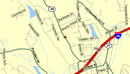
Danbury High School
Main Campus -Clapboard Ridge Road, Danbury, CT. 06811 (203) 797-4808
From Rt 7 Take Rt 7 North to I 84 East. Take Exit 5. Go to stop sign. Go straight on Downs St.. At light Turn L on Route 39 (North). Pass Farm Rd. High School is on the Right. From: I-84 West (Waterbury / Hartford Area)I-84 W. Take Exit 5. At light, Turn L onto Route 39 (North). Pass Farm Rd. High School is on the Right.
From: I-684 to I-84 East I-84 E. Take Exit 5. Go to stop sign. Go straight on Downs St.. At light Turn L on Route 39 (North). Pass Farm Rd. High School is on the Right. From: I-84 West (Waterbury / Hartford Area)I-84 W. Take Exit 5. At light, Turn L onto Route 39 (North). Pass Farm Rd. High School is on the Right.